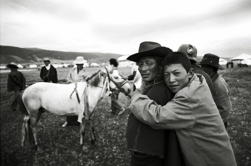
A blog reader named Stella wrote in asking about the story behind the picture above. I always like hearing the stories behind other people's images so I don't mind telling the stories behind mine. If you have a question about a particular picture, just email and I'll answer when I have a chance.
This photo was taken two years ago durning a Tibetan festival where herdsmen gather to celebrate and do business—literally to horse trade. The white horse was up for sale and it was initially the horse that drew me (I have a thing for pictures of white horses). So I was walked over and was enjoying the the back and forth discussion when the owner of the horse came over to check me out. We traded hellos and he obviously found me amusing. He asked if i was married or single. I said married. He asked me if I had children. I said I had one. He asked if it was a boy or a girl. I said a boy. He smiled and putting his fingers to his mouth, whistled loudly. "My son" he gestured. His son came over and gave him a big hug and I took this shot. Then I took a polaroid and gave it to them as thanks. The polaroids drew a crowd and I only had a few pieces of polaroid film left so I quickly exited. For the rest of the week I would be wandering around when I would hear the distinctive whistle, then I would look around and see the man in the distance. He would tip his hat to me and I would tip my hat back to him.
That's the story.
The print is available through my gallery in several editions as both as a traditional print and a platinum print.
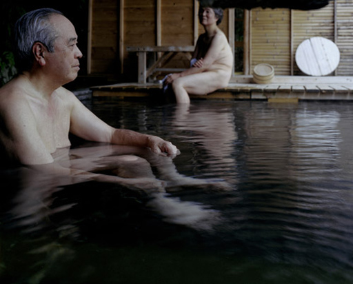
The American tendency is to associate any display of skin with sex and because of this I imagine many here would have a hard time wrapping their minds around the traditional Japanese sentos (public baths) and onsens (hot springs) you find all over Japan. In the most traditional village sentos families, neighbors, and co-workers bathe together, male/female, young/old with everyone gloriously and unabashedly naked. During my visits to Japan I was sometimes invited to join friends for baths after work and was always struck by the family atmosphere in these places—everyone with their little washcloths resting on their heads washing, gossiping, and just enjoying the warm soak.
Hiroyo Kaneko's series titled Sentimental Education gives us a bit of the feel of these places. When I compare these nude figures to the contrived "we're all so so naked and we don't care!' figures in Ryan McGinley's recent work I'm reminded that often the best way to showcase someone's humanity is by catching them in the middle of their most ordinary daily rituals.
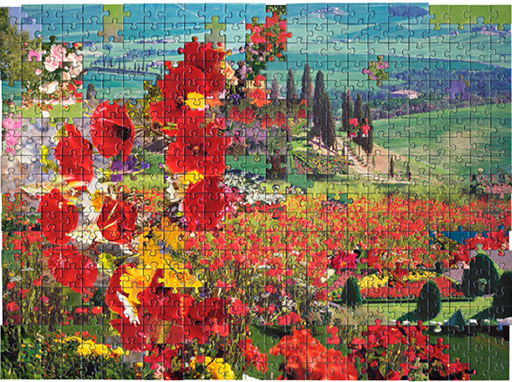
Over at 20x200 we're introducing a piece by Kent Rogowski today in conjunction with the opening of his show Love = Love tonight at the Jen Bekman gallery.
In this project Rogowski makes montages from puzzles with landscape scenes. The results would make the Cubists proud. I think they're great.
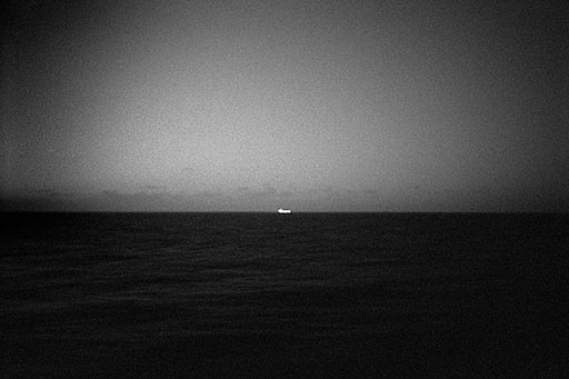
Have you ever stood on a beach and looked out over the water to some distant boat on the horizon and wondered about the people out there? I have, which is why I enjoy Mårten Lange's project The Sea so much. The little boats give scale to the sea's vastness, humanize the incomprehensible, and provide a space for your mind to fill with a story.
Lange is an editor at Farewell Books which specializes in delightful (but cheaply constructed) photo books.
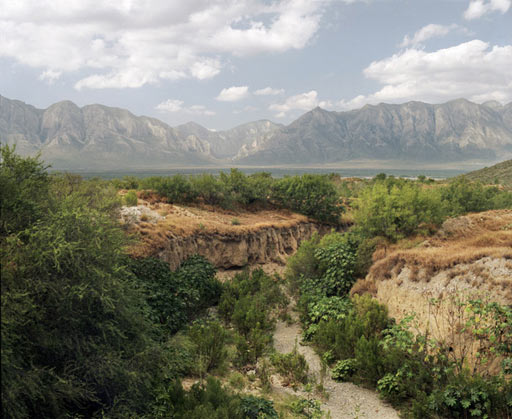
I received a nice email the other day from Alejandro Cartagena, a Dominican born photographer, who has lived for many years in the city of my birth, and the city closest to my heart, Monterrey, Mexico. Cartagena was a researcher on one of my semi-obsessions, a book titled Nuevo Leon, Imagenes de Nuestra Memoria and he is also responsible for a photo project I've been meaning to post titled Lost Rivers . If you've spent much time in that part of the world you know the significance of the often empty river beds that lead off into nowhere. In fact Monterrey itself is split in half by a lost river, the Santa Catarina, that is a chaotic mix of sand, overgrown palms, squatter homes, markets, and soccer fields. But you don't have to have experience in Mexico's northern states, to appreciate the melancholy of photographs of rivers vanishing into the dust; some photographs speak for themselves.
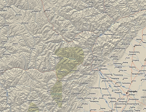
The city of Wenchuan where the recent earthquake in China was centered lies only a few miles away from the Longmenshan fault. The fault severs Sichuan province on the diagonal cutting it roughly in half. From ground the land to the east of the fault appears flat, but if you fly above it, you will see the earth slopes down into a huge basin (geologists call this the Sichuan Basin). On the other side of the fault, to the west, the land immediately deforms and flatlands quickly become foothills and foothills abruptly become an imposing labyrinth of impossibly high mountains and deep river valleys.
Until about 40 years ago the city of Wenchuan was one of the last major Chinese outposts before getting into the serious mountains. It’s lies at 4347 feet above sea level. Respectable, but a drive up the road you start hitting passes that are at 15,000 feet, then 17,000 feet...a day up the road you hit a 19,000 foot pass and those are the passes, the low spots between the mountains. The landscape is beyond human scale. For hundreds of years this was were where China effectively ended. Beyond were various kingdoms and fiefdoms of tribal peoples such as the Miao, the Naxi, the Qiang, the Yi, the Lisu and the many tribes of people we now group under the title Tibetans. Chinese mythology is full of stories of the mountains being the home to demons and spirits and in many old Chinese maps these mountains and the imposing deserts to the north of them represent the ends of the earth. The people in the mountains spoke foreign languages, practiced a foreign religion, and were ethnically distinct from the Chinese.
Mao Zedong made a conscious decision to take control of Sichuan's mountains, as well as Tibet’s 3 primary kingdoms. This area represented to him, and to the majority of Chinese today, part of that country's manifest destiny. Mao's government sent tens of thousands of Chinese up into the highlands as part of an organized "education and cultural assimilation" campaign both to teach city people the value of manual labor and to bring Chinese culture to the region. Local culture was systematically destroyed, monasteries were blown up, local religion and language were banned, and small villages were turned into Chinese cities. Living standards for many improved, but at the cost of their cultural heritage. Instead of small self sustaining organic communities living in symbiosis with the land the Chinese built medium sized cities often on grids, they dammed the rivers and relied almost exclusively on imports from hundreds of miles away to feed and cloth the people of those cities. Today there is hardly a city in the region without a majority Chinese population and in most cities vernacular architecture and customs are rapidly being erased.
As the land in these areas is so steep and harsh, most cities lie in deep river valleys. Because flat land is at a premium cities are often spread out over the thin strip of land on both sides of river bottoms. There are hundreds of rivers as this is China’s watershed and up every river and tributary you will often find a town or two. For the most part, dams have tamed these rivers providing power and most cities are connected by roads to the outside world. But these are tenuous connections. Most cities often only have a single road that passes through and connections to other cities and the outside world have to pass through some of the most rugged landscape in the world. Still, bit by bit, the Chinese have tried to take control of the landscape. Twenty years ago a bus ride to Wenchuan from the mega-city of Chengdu was a 14 hour ordeal. Today there are major highways with many tunnels cutting through mountains and the trip only takes about 3 hours or at least it did before the earthquake struck.
Beyond Wenchuan the mountain roads get narrower and even in the best of times have to be cleared regularly of debris from almost daily rockslides and washouts. Virtually all of western Sichuan as well as the provinces further north and west were recently closed due to riots. The riots in which ethnic Tibetans revolted against Chinese authorities and Chinese setters were the result of years marginalization, a kind of soft apartheid in which non-Chinese speaking locals are inexorably losing control of their historical homeland. The protests (and the crackdown in response) have been going on for months now in an area twice the size of Texas which has been almost completely cut off from reporters and travelers (Nicholas Kristoff managed to get in a rare report from the region in today’s NY TImes) The largest roads into this area run through Sichuan and right now apparently those roads are closed which makes the isolation even more complete. In addition to destroying roads homes and schools, the earthquake damaged hundreds of tunnels, bridges, and dams.
Looking at the images coming out of China I’m of course horrified by the destruction and loss of life wrought by the earthquake, in fact I worry that the actual death toll is much much higher than officially reported. The mountains are full of small towns and in village after village local Chinese governments have had habit of bulldozing indigenous architecture and erecting Chinese style concrete apartment buildings. While sometimes the buildings will have a locally inspired fillip as a nod to the tourists they tend to essentially be cheap concrete boxes, constructed fast and dirty. Judging from the pictures of the disaster it is these structures which have failed so dramatically turning entire cities into rubble. Many of those cities will be totally cut of for some time. Traditional villages in this area were even 15 years ago much smaller, one story affairs often built of wood and less susceptible to catastrophe than concrete apartment blocks perched on steep mountain ledges and at the bottom of deep river canyons.
My suspicion and fear is that the government will use the the world’s sympathy for the quake victims and rightful admiration for the heroics of the People’s Liberation Army whose soldiers working under the worst of conditions to detract from the harsh crackdown on Tibetans in the region. I suspect it will take years to find out what has really happened inland from to epicenter to tribal communities devastated by this this quake. My hope is that the quake will give the government in Beijing pause about overdevelopment in a region so inherently fragile where life has always been tenuous. Perhaps they will even take lessons from the indigenous people who have managed to live in harmony with this harsh environment for centuries rather than taking on the Sisyphean task of rebuilding and controlling the uncontrollable.
If you happen to be at the New York Photo Festival be sure to check out Andrew Miksys' show called BAXT, an exploration of the Gypsy community of Lithuania. The exhibition coincides with the release of a book of the same title. Baxt is the Roma word for Fate. Many of the images on the web don't do the prints justice. For example one of the signature pieces of the show is a portrait of a crying bride. On the web you can't see that she is crying which mutes the impact of the image. The show is on display at the Nelson Hancock Gallery through July 5th.
Mark Powell is a prolific maker of compelling enigmatic images. If you hang out with Mark for any time you realize his world follows him around. Strange things happen. He has kind of a force field that creates mystery.
I hadn't checked in on his website for a while and found that it is full of new work.
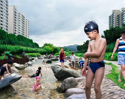
Seyeon Yun is a Yale MFA student with several knockout projects. Incomplete Journey is a astute wander through Korea... The portfolio is split into three chapters and, as the title suggests, it feels that more chapters are on the way. Homecoming is an equally powerful project delving into the lives of war veterans. Yun is part of the Yale MFA group show at Danzinger Projects opening on May 27th.
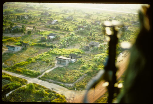
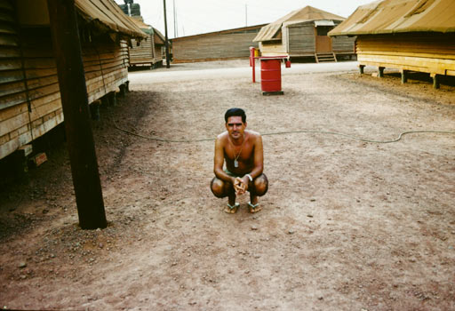
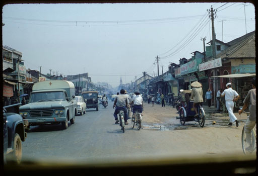
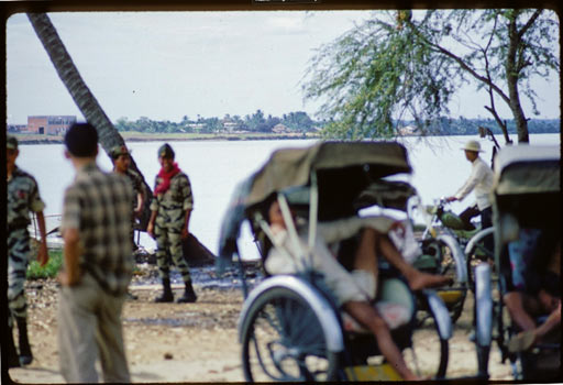
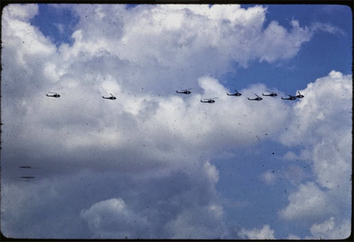
My dad was served as a doctor in the war we call the Vietnam war, the war the Vietnamese call The American War. He was there from 1966 to 1967. My dad's Kodachromes—there are hundreds of them—were my first sense of 'the other side of the world'. Many photos are of empty landscapes. There are shots taken from the backs of jeeps. The barracks. A whole roll is devoted to a praying mantis that lived in his dorm.
There are many shots of red dirt roads and palm trees. The palms and the red dirt must have made some deep psychic impression because during my trips there as a backpacker, my first impression was of a kind of overpowering and almost haunting dejavu. His photos largely turned away from the horrors he experienced. In the year he served more than 6,000 Americans died. 12,000 South Vietnamese died and 61,000 North Vietnamese. More than 30,000 were wounded. The hospital where he worked was one of the busiest in the country. When I was growing up we would sometimes talk about that year during long Texas car rides, but his answers to my questions always seemed like riddles to me. They still do.
I think I'm going to make the reader question thing a regular feature so here's another one by a reader named Daniel, a NY transplant from Wisconsin, who I met at the recent photo festival in DUMBO: "One thing still bothers me about our conversation. You said you make contact sheets. Were you talking about old fashioned contact sheets or digital ones? Isn't it easer to just do view them on the computer?"
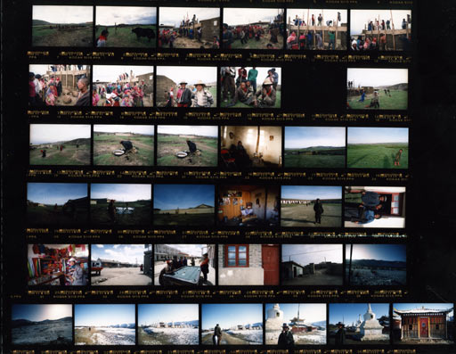
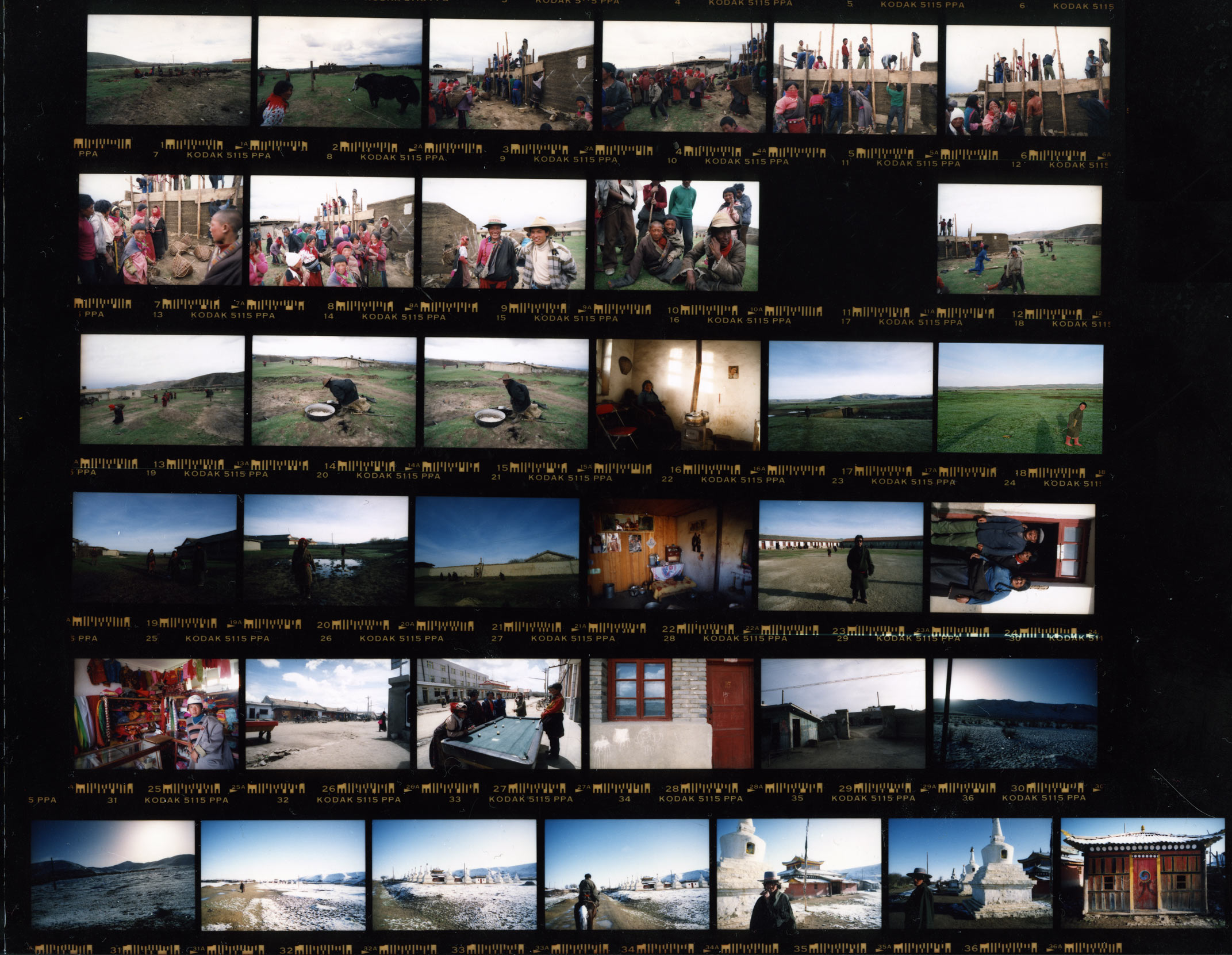
I do scan most of my 35mm film and I manage the files in Aperture but for project related photography I always make physical contact sheets (sometimes I now print them from the digital files because having them made traditionally is so darned expensive).
Why waste the paper when we can see everything bigger and better on screen? Mainly because I like to see the boundaries of the roll of film contained on sheet of paper. I rarely shoot more than one or two rolls of film in a day so a contact sheet represents a definable moment. Those edges of those days get lost on screen and make editing more difficult. I edit all my medium format film as contact sheets out of necessity as I don't own a decent medium format film scanner.
Above is a contact sheet from Amdo. Most of my film had been ruined by being frozen so I was shooting parsimoniously. In the first couple of frames you can see I wandered off the road to check out a house-raising. I ended up staying in this village for a few days. The roll of film covers a day and a half.
You can download a large version of the contact sheet here if you want to check it out in more detail.
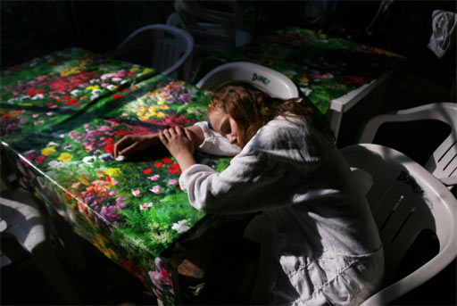
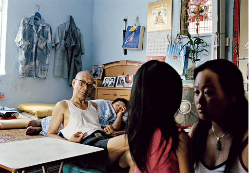
I don't buy into the whole idea of universality — the popular "it's a small world after all" belief that if you scratch the surface a bit we're all just plain folk who are the same underneath. Our culture, our families and our unique quirks mold our worlds and define the physics around which our lives revolve often blinding us to other worlds that exist beside us. I enjoy the work of artists who expose the intersections and rifts between worlds allowing us to peek into the unknowable territory that marks the boundaries of other people's lives. This is what Thomas Holton's The Lams of Ludlow Street does for me.
